888-306-2974

Process Management decisions have never been this informed.

Foley Specialty Services utilizes advanced equipment and software to help you make informed decisions that pave the way to a more financially and economically successful process. By teaming SLAM based LIDAR with a high definition 360° camera, you no longer have to rely on guesswork or one-sided information to make effective decisions about your equipment.

What is Reality Capture?

The Basics

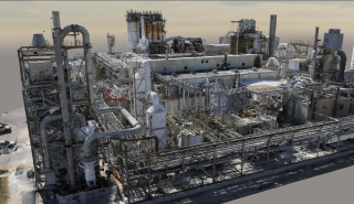
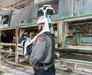
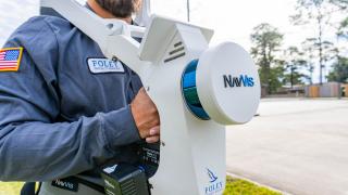
Reality capture is the process of collecting accurate real-time spatial data in areas of interest like production units, or even warehouses. Foley SS deploys equipment that uses highly accurate laser scanning (LiDAR) and photogrammetry to produce crisp, clear spatial imaging and point clouds that can be accessed by relevant parties from anywhere on the globe.
By using spatial data collected from the asset in real-time, your management team can plan ahead for repairs and maintenance to reduce downtime and maximize profitability. The collected 3D data is then labeled using details on specific points of interest to create a record of the asset that can be tracked for future use. Project planning is taken to a new level of speed and accuracy.

Our Process

Consultation

We work with you to determine your needs and formulate a plan to best serve your facility

Data Collection

Using specialized equipment, Foley SS’ highly trained and experienced technicians map the area that will soon become a digital twin of your assets.

Deployment

After the data capture and collection process is complete, our team of technicians focuses on processing the data and training your team members on its use.

Operations

From data and image interpretation, to future training support; Foley SS will be here every step of the way as you put your digital twin to work for you.

Benefits of Reality Capture

Reliability

This level of accuracy and round-the-clock accessibility is necessary for decision makers that are sometimes thousands of miles away.

Improved Output

Having access to this data, your engineers will be able to plan and carry out projects faster and more efficiently than ever before.

Agility

After a scan is complete, it is always possible to seamlessly integrate a new scanned area into a previous model; so as your project evolves, so does your digital twin.

Reduced Travel Expenses

Since all stakeholders can log on and examine uploaded data from anywhere in the world, each user gets full access to the data and can derive different spatial insights from real-life structures they do not have real-time access to.

The Device

Foley Specialty Services employs is an all-in-one reality capture device. It captures 3D measurements with two multi-layer LIDAR sensors in combination with SLAM software to deliver survey-grade point cloud quality. Four cameras are positioned on top of the device to take high resolution images in every direction for a complete 360° view. The system has streamlined the scanning process by being up to 10 times faster than traditional terrestrial laser scanners.